The Index Traverse
22 July 1971
A Lot of Famous Climbers then Names I Didn't Recognize
Mount Index is situated just off US Highway 2 near the town of Index,
Washington.
In spite of the fact it is under 6,000 feet in elevation it is quite an
impressive site from the highway.
In fact,
on more than one occasion I heard people exclaim
“I bet no-one climbs that!”
Of course,
that placed it high on my list of priorities.
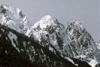
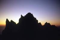
Mount Index consists of three summits:
the South, Middle and North,
in descending order of height and shown left to right in this winter picture.
Traversing the Peaks from North to South
(right to left in the picture)
is referred to as the
Index Traverse.
The South Peak is a moderate scramble,
so is frequently done by ambitious hikers.
The North Peak is the most prominent feature when viewed from the highway
and is a challenging climb by itself.
To do the Traverse,
rappel into the notch toward the Middle Peak and climb from there.
From the Middle Peak descend toward the South Peak,
climb the South Peak and descend via the hiker's route.
Brad wanted to climb the North Peak of Index,
but I told him I would only do that if we continued on to do the entire
traverse.
Partners for a North Peak climb are difficult to come by,
so he agreed.
For research I prevailed upon a pilot friend to fly me around the
mountain to take pictures.
I also found vantage points from which I could take pictures of the
mountain in winter.
And I read
Fred Beckey's
(1st Traverse, 1950)
account in
Challenge of the North Cascades.
I consulted Dave Christensen,
who had done the route a short time before and I talked to
Bill Sumner
(2nd North-South Traverse, 1967).
Combining the difficulty,
lack of easy escape routes and length of the climb results in the rating
of Grade V
(on a scale of I to VI).
Sumner told me:
Once you attain the summit of the North Peak,
90% of the people in Mountain Rescue will not be able to reach you.
Once you rappel toward the Middle Peak,
100% of the people in Mountain Rescue will not be able to reach you.
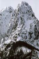
In this winter picture of the North Peak,
the large snow patch immediately above and right of center is commonly
referred to as
“The Basin.”
In the summer,
it is a patch of greenery and one imagines strolling through it as a
break in the difficult sections one encounters below and above.
The Middle Peak is to the left and behind the North Peak.
Years after our climb,
in his
Cascade Alpine Guide,
Fred Beckey wrote:
[The Middle Peak]
is certainly one of the most inaccessible spots in the Cascade Range,
offering no practical route aside from the difficult traverse from the
North Peak
(route of first ascent)....
Only a very competent team should consider the climb by any route;
the consequences of either accident or bad weather could be serious.
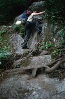
We wanted to get an early start on the mountain,
so we drove up in the afternoon and spent the evening
“hiking”
up to Lake Serene at 2,500 feet.
This area gets lots of moisture and can get quite overgrown.
The day was exceptionally hot and we sweated our way up the trail,
fending off mosquitoes.
The situation changed suddenly as we crested a ridge and dropped down
to the lake.
Lake Serene is in a depression at the foot of Mount Index and is shaded
most of the day even in Summer;
cold air pools in this depression,
and the lake was still mostly frozen,
despite this being late July.
We were soon shivering and putting on all the extra clothing we had.
This was the coldest night of our climb,
but the break from mosquitoes was welcome.
After a chilly night,
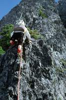
we headed to the base of the North Peak to start roped climbing at 8AM.
Brad climbed unbearably slowly,
especially when in the lead,
and had problems keeping to a good route.
After leap-frogging for 10 leads,
it was 4PM and we were barely halfway up the North Peak.
Brad realized he was slowing us down too much and let me do all the leading
from this point.
I started belaying him using my
jumars
so I could maintain tension to help him along without tiring my hands
gripping the rope.
Regarding the so-called
“Basin”:
the slope is quite steep but extremely brushy.
It is made slippery by moisture seeping from cracks in the mountain.
We climbed together roped up,
assuming a fall would be stopped by the rope catching on the brush.
After the Basin,
we could climb on relatively clean rock.
While climbing this section I kept hearing a hum sounding distinctly like
that of a falling rock as it whizzes past at over 200mph.
This was disconcerting,
but also puzzling:
I was sure there was no-one above us,
and the slope was not steep enough for rocks to free fall far enough to
build up significant speed.
Could someone be throwing rocks?
Finally,
I heard the noise again but it was a steady hum.
Looking over my shoulder,
I saw a hummingbird;
apparently the little hummers had been checking me out.
What a relief!
With me leading and helping Brad on the belays we reached the summit at
7PM.
This was much later than planned.
We had started with 2 quarts of water each and had managed to collect
more in the Basin,
but we were running low again.
We considered starting on to the Middle Peak,
but decided to bivouac on the North Peak and continue in the morning.
This picture was taken from near the same spot as the second picture in
an account of a 2005 climb.
At the top of the North Peak we found an
aluminum 35MM film canister
typical of registers left by the original ascent party of difficult
summits.
It contained a small sheet of rolled up paper,
a pencil stub,
Lou Whittaker's
Stevens Pass ski patrol id and
Jim Whittaker's
driver's license.
When the Whittaker brothers climbed the North Peak in 1949,
there was no pencil in the film can and they left what documents they
had to prove they had been there.
Among those who signed the register were
Fred Beckey
and
Pete Schoening.
We were proud to be able to add our names and stuff the documents and
pencil stub back into the can.
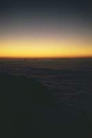
The night on the summit was surreal.
Low clouds had moved in to form a sea around us,
with other summits sticking out like islands.
We could hear,
but not see,
cars on US Highway 2 drive by with their safe and warm
occupants while we tried to make ourselves comfortable in our rocky
isolation.
We started out early the next morning by rappelling into the notch between
the North and Middle Peaks.
Unfortunately,
we misjudged the location of the notch and wound up well below and to the
side.
We then spent half of the day doing VERY difficult climbing
to get back on route.
Bill Sumner's warning that no-one in Mountain Rescue would be able to
reach us weighed heavily on my mind.
I was determined to do the route
“free,”
which is to say:
using the rope and pitons for protection,
not to gain an advantage.
On an extremely difficult and rotten section going up the Middle Peak,
I felt around with my foot and finally found something to stand on.
I looked down to see I was standing on a piton I had used for protection,
and had to find another foot-hold before climbing on.
While climbing this pitch,
I kept hearing rocks bouncing down the steep narrow gully below,
with the clack-clack-clack increasing in frequency as they fell,
seemingly forever.
This was quite disconcerting,
as I assumed I was knocking the rocks off as I climbed and I would soon be
following them.
Finally,
Brad yelled:
“Hey, listen to this!”
and threw another rock down to listen to its long fall.
I was not kind in my reply.
On the steep pitches,
we were hauling our rucksacks using our
reepschnür.
With all the leading,
hauling and belaying I was doing,
the jumars were invaluable for conserving my ability to grip small things.
After two or three long pitches of rotten rock and poor protection,
I reached a tree and felt safe for the first time in hours.
We were out of water and my throat was dry.
When Brad reached the belay point,
he pulled an orange out of his rucksack,
gave it to me and declined a share.
I forgave him for the rock throwing incident.
Now re-energized,
I continued on;
the pitches were getting easier.
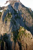
We soon reached a snow patch
(just below and right of center in this picture from the North Peak).
As we sat and ate the snow I recalled that Fred Beckey had mentioned this
small patch of snow as a welcome relief to their thirst in his account.
From the snow patch,
a few relatively minor difficulties brought us to the Middle Peak.
We found a 35MM film can with the usual wad of paper and pencil stub.
There were 5 sets of names on the paper,
starting with Beckey and Schoening.
We added Dave Christensen's and Greg Markov's names to the register
(they had done the climb but had not found the register).
Then we added our own.
One of the climbs had been a solo while others were teams of two,
making us the 12th and 13th climbers on the summit,
remarkable for a mountain adjacent to a major highway.
The solo climb was done by Ed Cooper on a South-North Traverse.
One team had climbed the east face and one the west face,
so we were the 4th team to do the North-South Traverse.
It was too late to proceed,
so we spent another bivouac night.
We were completely out of water and ate snow to get some liquid.
A normal pace and good route finding would have had us back to the car by
this time;
now we were operating on our spare rations.
The next morning we started out and soon found water running out of a
melting snow field.
After drinking to our content and filling our bottles,
we continued on to the relatively easy downclimbing and rappels into the
Middle-South notch and climbed up to the South Peak summit.
The descent from the South Peak should be easy but we were tired and
found ourselves having to downclimb steep snow without proper
equipment.
Brad was especially cautious on the snow,
to the point of increasing the danger.
This slowed us down considerably and we got back to the car at 9PM.
Brad was so beat he handed his car keys to me and asked me to drive
home.
When I got home,
I sat down on my bed in the clothes I had been wearing for the past
three days,
fell back with arms outstretched and woke up 10 hours later in exactly
the same position I had fallen.
After the climb,
Bruce Carson
was interested in the route so I provided him with detailed notes regarding
the route plus cautions about getting off route.
He typed my notes,
combined with other climber's descriptions of the North Peak route,
encased it in plastic and handed it out to friends.
I still have my copy.
Three years after this climb,
I met Eric Schwan,
who,
upon hearing my name,
asked:
“Did you do the Index Traverse?”
When I told him I had,
he remarked that the register started with names of
“a lot of famous climbers and ended with names I didn't recognize.”
He had put his name after ours in the Index register.
We joined forces for the
Mount Goode
climb.