Rainier: Liberty Ridge
16–18 July 1971
To quote one of the Climbing Rangers:
Liberty Ridge boasts the
highest rescue rate
of any route on the mountain....
Statistically speaking,
your party has about a 5% chance of needing rescue.
A much higher percentage of people end up having some kind of difficulty
from minor inconveniences to many having a
major epic.
According to park records,
53% of parties attempting this route actually reach the summit.
While Liberty Ridge accounts for only 2% of ascents,
it accounts for approximately 25% of fatalities on Mount Rainier.
One reason for the history of problems on this route is it is often not
possible to accurately gauge approaching inclement weather
(generally coming from the other side of the mountain)
once on the route.
Modern technology now helps with such uncertainties,
but also prompts people to take greater risks.
A very detailed description of the route can be found
here.
This pamphlet was published long after our climb!
A recent example of how things can go wrong on this route can be found
here;
although the article claims
“Liberty Ridge is the most technically difficult and dangerous route to the top of Rainier,”
there are in fact a number of routes far more difficult and dangerous
(eg, Willis Wall and Ptarmigan Ridge).
On Friday,
Bob Sloan and I checked in with the park rangers and started from the
White River Campground at 1:30PM.
We hiked to St.
Elmo Pass,
then across the Winthrop Glacier to Curtis Ridge.
The Winthrop Glacier was crevassed so we travelled roped together.
The crevasses required a bit of zig-zagging plus crossing a couple of
interesting snow bridges.
We maintained a leisurely pace,
knowing that we would camp before reaching Liberty Ridge.
On the approach traverse we kept trending higher and wound up at a flat
spot at about 7,500 feet on Curtis Ridge with a cliff between us and
Liberty Ridge.
By tossing rocks off the cliff and timing them,
we determined it was about 500 feet down to the Carbon Glacier we should
have been on.
This spot was fairly level and dry;
we also found a source of water trickling off nearby snow.
It was an ideal campsite.
While we prepared and ate dinner,
we studied Liberty Ridge and the crevasses we would have to navigate
through before starting to climb.
We started our descent at 7:30am the next morning,
heading down Curtis Ridge and onto the Carbon Glacier.
At 5.7 miles in length and 700 feet in thickness,
the
Carbon Glacier
is the largest glacier in the 48 contiguous states.
It extends from about 9,600 feet at the base of Willis Wall to a moraine
at 3,500 feet.
Its size can be attributed in large part to the accumulation of
avalanches from Curtis Ridge,
Willis Wall,
Liberty Ridge and Ptarmigan Ridge,
in addition to its location on the north side of the mountain.
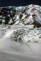
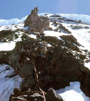
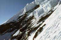
The view as we approached gave us a good assessment of the anticipated route.
Our high camp would be to the right of the
“fin”
known as Thumb Rock at about 10,800 feet on the ridge.
With an early morning start we planned to traverse onto the right side
of the ridge
(the '1955' route)
and up snow slopes until we could traverse back onto the left side of
the ridge for some very exposed climbing before the final easy slopes to
the summit.
The actual route we took is in red.
This picture is taken from an altitide of 7,000 feet.
There is still about 3,800 feet to get to base camp and another 3,300
feet from there to the summit.
As we approached the ridge,
trying to circumvent the crevasses to get to the left side of the ridge
(as advised by Bill Sumner),
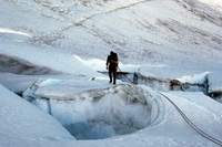
the complexity of the crevasse systems increased.
We spent a great deal of time jumping over them and belaying across snow
bridges.
Finally,
it appeared that one last large crevasse blocked our way.
I removed my pack and climbed down into the crevasse to a snow bridge
inside,
then hacked hand and foot holds up the other side
(all with a belay from Bob, of course).
After pulling the packs across,
I belayed Bob.
This was the final major difficulty getting to the ridge.
We wound up several hundred feet from the base and had to descend a bit
to get onto it.
Having attained the ridge,
we began to climb directly up the rotten rock in deference to the ice
cliffs looming over 3,000 feet above.
As we climbed we saw a friend
(Dave Anderson)
and two companions approaching the base of the ridge on the right side;
apparently they had noted our difficulties and thought they could do
better.
Their approach involved going toward the left side then turning right
through a depression at the base of the ridge to attain the snow slopes
on the right side of the ridge base.
At that point there is little protection from the ice falling from the
ice cliffs high up on the right of the ridge.
After they were on the ridge,
a huge avalanche came off the ice cliffs;
it missed their tracks but served as a good indication of why the left
approach is preferable.
Here is a
time-lapse of an avalanche
down the right side of the ridge taken in 2020.
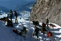
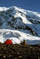
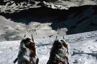
We reached the high campsite next to Thumb Rock at about 10,800 feet at
4:30pm and were soon joined by Dave Anderson and his two companions.
We learned that
Bruce Carson
had been the leader of his party,
but had gotten sick on the approach and turned back.
At 5:30pm yet another party arrived;
things were getting a bit crowded –
there is very little space and even less level space at this site.
We all worked madly to create some good places for tents.
The last party included a woman
(Tory Stevens)
I had taught in the beginning climbing course the previous summer.
She had taken no courses since then but was the apparent leader of the
party and it appeared that others in her party were of comparable
experience.
To have such a crowd is highly unusual;
normally one expects to be on this route alone.
In the background the Carbon Glacier can be seen winding down the valley,
littered with the debris that fell with the avalanches off the walls and
ridges of its origin.
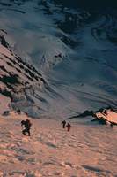
We woke at 2:30am the next morning and started for the summit at 3:30am.
Dave Anderson's party was ahead of us,
but Tory Stevens' party took a different route from camp.
The route Anderson took was up a gully above camp
(the '1935' route, aka the "Gunsight”)
and was recommended by Sumner and Carson.
We found it unpleasant going,
with verglas on the rocks interspersed with cruddy snow over rotten ice.
We turned back and Anderson's party soon followed.
That put us behind the two ropes in the Stevens party,
who had gone to the right
(the '1955' route).
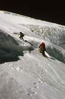
The ice cliffs loomed above,
but at this altitude any ice fall would miss us.
Things went well and we managed to pass both ropes of the Stevens party on
the steep slopes going up the side of the ridge at about 11,500 feet.
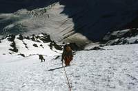
We made the transition to the high,
steep slopes of the ridge easily.
Bob and I chugged along like steam engines as we kicked steps,
periodically switching leads between us and switching off with the
Anderson party as well.
The night had been warm,
making the snow soft;
having a number of people to kick steps sped us up,
as did a bit of friendly competition between the parties.
If the slope had been icy we would have wanted protection and belays,
slowing us down considerably.
This article
has a picture showing a dark "smudge" near the center top; this is the slope
we were on, and is perhaps the mark left by the snow that sluffed off and killed six climbers.
The slope is not visible above the rock cliffs,
but the ice cliffs shown in the next picture are visible at the upper left.
Nearing the altitude where the slope begins to ease
(above the "Black Pyramid)
we could look across the slope to our left and see how steep the going
was.
These ice cliffs overhang
Willis Wall.
We heard numerous crashes of ice falling down the wall the night before,
but did not see any spectacular
“calving”
during our climb.
Willis Wall has been climbed,
but only
very infrequently
and by climbers whose desire to live is questionable.
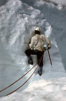
The lead rope could rest as we exchanged leads,
taking in the exhilarating view down the steep slope to the glacier
thousands of feet below.
The slope was easing off,
making the exposure below more apparent.
These last three photos illustrate where the ridge is the
most
unforgiving.
It is over 3,000 feet to the Carbon Glacier below.
Near the summit we found the easy way through the ice cliffs and belayed
each other through the crack systems.
Above this difficulty it is an easy slog to the summit.
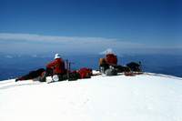
The Stevens party was far behind as we made the summit at 10:30am.
It was so calm we broke out the stoves to make tea,
Jello and hot chocolate while we waited for them to show up.
In the distance is
Mount St Helens,
still nicely symmetric and
(at 9,677 feet)
about 1,300 feet taller than is today.
Recalling an
incident on Mount Baker,
I did not want to leave without knowing the inexperienced party was all
right.
After a one hour wait,
I descended solo down the route about 200 vertical feet to spot them.
All was fine,
they were just slow.
Finally,
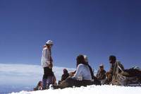
everyone was on the summit
(that's me standing)
and appeared to be fit for a safe descent down the
“easy
”Emmons Glacier route
in the excellent weather.
After having spent 2 hours on the summit,
we took off down the Emmons Glacier,
descending the first 4,000 feet in just over an hour.
We arrived at the car in 3 hours and 45 minutes from the summit,
including a 15 minute stop to chat with the ranger at Camp Schurman.
It always seems one's energy level increases on the descent and speed
increases accordingly,
and this is especially true after a successful climb on a marvelous day.
I later learned that 7 of my former students summited Rainier that day:
Tory Stevens (Liberty Ridge),
Loren Ruster and Jim Truitt (Emmons),
Rick Kirsten, Dick ?? and Willa Halperin (Kautz),
and Sid Honey (Ingraham).
Dave Anderson was killed in 1998 when the rescue helicopter evacuating
him from a back-country ski accident crashed.