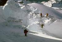
Rainier:
Nisqually Ice Fall
May 1970
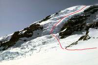
Crevasses usually form as a result of a glacier moving across a change
in slope.
In the case of the Nisqually Glacier,
a dramatic change in slope occurs as it slides from the summit,
over a cliff and down into the valley below.
The result of this transition is called the Nisqually Ice Fall.
The route up the ice fall starts from a high camp at Camp Muir
(10,000 feet)
and descends to the foot of the ice fall,
where one faces challenging route finding through the jumble of ice to
the summit
(14,410 feet).
To get a feel for scale,
note the skiers at the bottom left;
they are not on the glacier and are MUCH closer than the ice fall.
The red line only indicates the general path of the climb–
the actual route through the ice fall was much more complex and varies
from year to year.
The break in the line shows where we descended to the glacier to cross to
the ice fall.
The crest where the red line ends is about 5,000 feet above us from this
vantage point as we ascended to Camp Muir,
so the elevation gain tomorrow will be well over a mile!
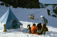
Dave Christensen's friend
Paul Myhre
(standing)
invited us along for a climb of the ice fall;
Dave and I would be one rope and Paul and a friend were another.
We spent Friday night at a campground near the entrance to Rainier park,
then started for Camp Muir early the next morning.
There were a lot of climbers at Camp Muir,
so we did not get a very level site for our tent.
Soon after erecting the tent we discovered that a helicopter was
ferrying things up for the park service and we were on its landing site.
The pilot was able to land anyway and was quite apologetic about the
disturbance.
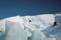
We got a relatively late start the next morning and were still
negotiating the ice fall as the sun came up.
One generally tries to climb this sort of terrain before sunrise because
the ice is more secure.
At least we could get pictures–
though a bit grainy here due to the low light level.
Belaying through the jumble of ice was quite fun.
There were smooth slopes between the huge jumbled blocks of glacier ice.
However,
these were not safe;
not only were they steep,
they were riddled with hidden crevasses.
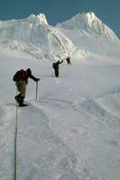
As we neared the top of the ice fall,
another party caught up to us.
Not long after this section,
we had smooth sailing to the summit.
I was following Dave on our rope and Dave was following the other rope
teams.
Not all of the danger was past–
as the slope eased,
Dave
(and everyone else)
went out of sight.
Suddenly I fell through the snow into a hidden crevasse.
I immediately extended my arms with my ice axe and stopped the fall with
my arms and pack wedged into the snow and my feet dangling freely into
unknown depths.
The rope came tight.
Concerned that Dave might come back to investigate why,
increasing the danger for us both should I fall through,
I managed to quickly lever myself out using a technique known as
mantling.
Knowing I was probably still standing on the snow bridge and still in
danger,
I did not bother to investigate the crevasse and moved on.
Why was there a crevasse there?
The fact that Dave had disappeared from sight due to the change in slope
was a clue;
as I said at the very beginning,
crevasses form as the ice flows over a change in slope.
Why didn't the others fall in?
They must have had the good fortune to step on stronger portions of the
snow bridge hiding the crevasse.
As we cleared the ice fall I could tell that I was starting to come down
with
HAPE
(high altitude pulmonary edema).
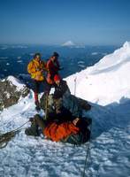
In this picture at about 13,000 feet near the top of the ice fall my
expression shows I'm already a bit unhappy (the white on my nose and
cheeks is
clown white makeup
for sun protection).
We certainly did not want to descend the ice fall and the terrain does
not permit an easy traverse back to Camp Muir* –
consider trying to traverse right from our route shown in
this picture.
Traversing left and down would put us around the mountain and miles
from any help.
We had no viable choice but to continue the planned route to the summit
and down the Ingraham
(aka tourist)
route back to Camp Muir;
this would have the added advantage of putting us in contact with other
climbers
(and potential help)
more quickly.
I trudged on the remaining 1,400 feet vertical to the summit,
gasping for breath and getting worse by the minute.
After we had traversed the summit and descended to Camp Muir I collapsed
in the snow as everyone else packed up tents and sleeping bags,
taking most of my gear into their packs.
The mountain in the distance is Mount Saint Helens,
pre-eruption.
Dave recalls being told by the rangers at Camp Muir that an avalanche
had swept down the ice fall that morning.
It must have happened after we got above it since we did not see any
evidence of an avalanche on the way up.
Once everything was packed the rest of the team stood me up,
pointed me downhill and gave me a push.
I staggered down and was soon starting to improve.
By the time we reached 7,000 feet everyone started stuffing my gear into my
pack.
At Paradise
(5,400 feet)
it was as though nothing had happened.
This was the only time I suffered from
HAPE.
I think there were two contributing factors.
First,
even though I was in good physical condition,
it had been some time since I had been much above sea level.
Second,
I consumed a very high protein,
low carbohydrate dinner the night before;
modern medical research indicates favoring carbohydrates over protein.
It was clear at the time of our climb
Paul Myhre
was an accomplished climber,
and he told us of a number of impressive ascents.
He is responsible for a number of first ascents in the North Cascades
and elsewhere.
I noticed ½
of one of his fingers was missing;
assuming there was a dramatic story to be told,
I asked about it.
It turns out he was a bit careless with a table saw.
Some time later I learned Myhre was a climber of note,
with many first ascents recorded in Beckey's guides.
He tried to convince Dave and me to climb
Mount Waddington
with him but we both felt it was beyond our capabilities
(we were but one year out of the beginner climbing course).
What Does HAPE Feel Like?
Try this:
breathe in as much air as you can,
expanding your stomach and chest to the limit.
Now try to breathe in more;
that's what it feels like when you try to breathe in.
Next,
breathe out as much air as you can,
compressing your stomach and chest to the limit.
Now try to breathe out more;
that's what it feels like when you try to breathe out.
Now imagine that you are getting desperate for oxygen but can breathe in
and out small amounts and only with great effort.
Basically,
with HAPE your lungs are filling with bubbles and your ability to
breathe in or out is progressively limited until you drown.
Add to this the fact that at 14,000 feet there is only about 60% of the
air per unit volume as sea level and you have a serious problem!
The problem resolves itself when you return to a sufficiently low
elevation.
* There is a route and variations that pass along the face of
Gibralter Rock.
The Gibralter Ledges route may in fact have been the route taken for the
first ascent of Rainier.
However,
these routes are usually done in winter due to the extreme rockfall danger.