Ptarmigan Traverse,
North Cascades
31 July – 08 August 1971
My Life As A Mountain Guide
One of the advantages of acting as an assistant or instructor in the
University of Washington climbing courses was meeting many new people
interested in climbing who would later serve as climbing partners.
In the case of the Ptarmigan Traverse,
two former students approached me and asked me to lead them.
We started planning for the trip and the potential participants began
to fluctuate wildly,
with more opting in than opting out.
I participated in the free-for-all by inviting
Barb
(Barbara),
who
(much to my disappointment)
insisted on bringing along her boyfriend Pete.
The final roster was:
me,
Bob Sloan
(only the first few days),
Sid,
Loren,
Jim,
Scott,
Barb,
Pete,
and Denny.
All except Bob were former students.
The
Ptarmigan Traverse
is a classic
alpine style
climbing expedition.
Although some describe it as a
“hike,”
it requires ice axe,
crampons,
ropes,
knowledge of glacier travel and rock climbing techniques plus good
route-finding skill even if one does not climb any of the summits along
the way.
The traverse is named after the original members of the Ptarmigan
Climbing Club who pioneered the route in 1938.
This ambitious undertaking was not repeated until 1953 and again in the
late 1950s.
Few parties had done it in the 33 years since the first traverse,
so we would be joining an elite few.
One of the few references for the route we had was my copy of Tom Miller's
The North Cascades,
a book best characterized as a coffee-table book for climbers.
As the author of an account of a 2003 traverse said:
"Young climbers who started exploring the North Cascades in the 1970s,
before modern guidebooks were available,
jealously thumbed through the book in their friends' collections or on
library shelves."
I still have the book and,
no,
you can't borrow it.
But feel free to browse it if you ever visit.
Even rarer at the time was Fred Beckey's
Climber's guide to the Cascade and Olympic Mountains,
published in 1949 but still a definitive resource.
I was fortunate to have a friend who allowed me to photocopy pages from his
volume after swearing I would not let it out of my sight until it was
returned to him.
In 1971,
we needed no permissions to enter the newly created North Cascades
National Park and associated wilderness areas.
One simply packed up and took off.
Now I suspect one has to make reservations and schedule camp sites.
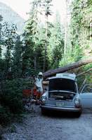
The traverse begins by leaving a car at the
“end.”
In our case,
the end was at the south so
Bob Sloan, Scott and I left my car at the south end and drove in
Bob's car to the north
“start.”
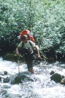
The road was not well-maintained;
spring avalanches had blocked it 3½ miles from the trailhead,
making our hike in to Cascade Pass 7 miles.
We continued up and north from Cascade Pass to make camp on
Sahale Arm–
a total of over 9 miles and 2,500 feet elevation gain from the car.
In spite of the heavy packs
filled with ropes, rock climbing gear, ice axes, crampons, and provisions for
9 more days,
we made good time.
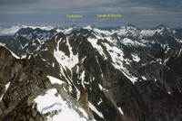
Note Forbidden Peak at far left and Sahale Mountain at far right.
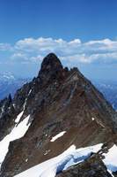
We began the next day by climbing
Sahale Mountain
to get the expansive views of the North Cascades it provides.
From there we looked south to the terrain Scott and I would be
traversing over the next 8 days.
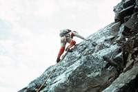
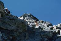
We continued on north over Sahale with the intent of climbing
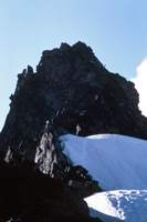
Boston Peak
(pictured),
whose main claim to fame was its first ascent was part of the
pioneering 1938 traverse.
We found the rock on Boston Peak to be too rotten and decided to
turn back and prepare for another climb the next day.
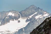
Scott wanted a rest day,
so Bob and I got up early and traversed to the unnamed glacier below the
south face of
Forbidden Peak,
and climbed up to a notch in the east ridge
(red line)
to climb the Northeast Face route.
The route is class 3-4 and sometimes climbed unroped.
However,
the exposure is breathtaking and a few people have proven a single slip
is fatal.
We roped up and placed protection,
climbing together when it felt safe and belaying at other times.
Between the long traverse to and from the mountain and the climb itself,
it took us 12 hours to get back to camp,
exhausted.
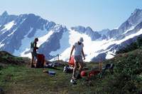
The next day was a rest day for us.
We descended the Sahale Arm trail to Cascade Pass and hiked to a vantage
point south of and above the pass to wait for the remainder of the party
to join us.
It was an idyllic day laying in the heather,
being dive-bombed by humming birds.
The park ranger on duty was lonely and joined us for a little company
and to watch a bear going up the Sahale Arm trail
(now across the pass from us)
about to confront a hiker coming down;
we yelled in warning,
to no avail.
The hiker finally saw the bear and turned back.
Eventually the bear left the trail and the hiker continued his descent.
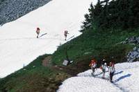
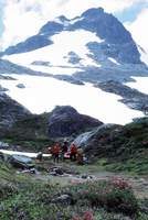
The other members of the party arrived
(telephoto shot)
and we set up camp on a level spot Bob,
Scott and I had identified south and above the pass.
As we made dinner,
the park ranger showed up with his gear and asked if we minded it he set
up his tent next to us–
he was concerned the bear would visit at night.
North Cascades National Park
was in its infancy and there were no facilities.
Rangers were sent into the park with camping equipment and a radio that
was frequently out of range of a base.
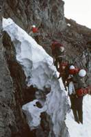
The next day,
we packed up and headed to
Cache Col.
We dropped our packs,
donned climbing gear and split the party.
Bob led
Mixup Peak
(I had climbed it on a previous occasion)
and I led
Magic Mountain.
My group descended Magic Mountain,
picked up our packs and headed to Kool-Aid Lake,
named by early campers who claimed to have used the entire lake
(really a small pond)
to make Kool-Aid.
During our descent,
clouds moved in and we were able to find the very small
“lake”
purely by chance.
On the descent from Mixup Peak,
Bob picked up his gear and headed out,
leaving the others to find us in the fog.
That left me as the only experienced climber with 7 novices;
this created problems for the rest of the trip.
In this picture on Magic Mountain,
I was wearing my warm weather outfit:
wind pants with shorts.
The wind pants keep the sun off the legs,
while the shorts protect the wind pants seat.
Good climbers don't use their knees,
so no protection is needed there.
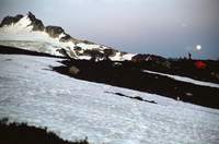
At Kool-Aid Lake,
my team set up tents and prepared dinner.
In an attempt to establish contact with the others,
we yelled periodically,
trying not to confuse them with echoes.
Finally,
we heard them yelling back and guided them in to camp.
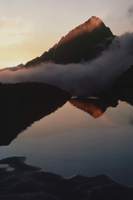
As the sun set,
the clouds began to clear and I was able to get a nice picture across
the still half-frozen lake to its outlet,
with Mixup Peak and
Johannesburg Mountain
in the background.
The next day dawned clear;
this was fortunate because we had to locate the infamous
“Red Ledge,”
an improbable formation providing the only
“easy”
path to the next pass at the Spider-Formidable col.
We found ourselves on steep snow with no place to stop and don our crampons,
so I wound up chopping steps with my ice axe to provide safe footing to the
ledge.
Parts of the ledge are downsloping loose rock that invite a dangerous fall
onto a long,
steep snow slope.
At the col,
we dropped our packs and started to climb
Spider Mountain.
This was an unfortunate choice
(as outlined in the link).
We found the rock to be too unstable,
stopped 100 feet short of the summit and started back down.
The lack of another experienced person told the tale;
had we been able to split the party into two manageable ones,
one going to Spider and the other to Mount Formidable,
the number of people generating rockfall would be greatly reduced.
As it was,
with seven novices to supervise it took several hours to safely descend
the mountain.
The failed attempt on Spider brought morale down.
In our planning meetings,
we had agreed each person would bring a dessert for everyone else and
fix it on their assigned night.
We had one extra dessert,
and,
thinking this was the low point of morale
(it wasn't)
we had two desserts that night:
I prepared a cheese cake as the additional treat.
I assured everyone the rock was better around Dome Peak,
so we decided to bypass Sentinel,
Old Guard and Le Conte.
The next day,
we made a short stop at Ying-Yang Lakes under Le Conte
(pictured)
and headed on to White Rock Lakes.
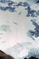
We followed the diagrams from the first traverse and wound up descending
to a cliff above the South Cascade Glacier.
I consulted the topographic maps and determined we should have continued
left up the Le Conte Glacier
(rather than descend right)
to reach the upper slopes of the South Cascade Glacier.
We had to climb back up 1,000 feet to get back on route.
THIS was the low point of morale.
For a sense of scale in this picture,
look in the lower left corner for the people climbing back up from the
cliff.
Updated guides have corrected the error in the route description.
At least we had better topographic maps than the original party,
but GPS was still many years in the future.
I wanted to make sure there would not be another route-finding error,
so I planned to go as fast as I could to a col where I could confirm we
could descend to the planned camp site near White Rock Lakes.
Barb's boyfriend Pete had been giving me a hard time for days;
now he called me a
“shrimp.”
I had suffered his insults in silence,
wanting to maintain peace in the group and confident everyone else could
see he was an ass;
but this was the limit.
When we got back to the Le Conte Glacier and roped up,
I put Pete on my rope,
knowing that
(a) he weighed much more than me and would be a good anchor should I fall
into a crevasse,
and
(b) he would want to prove he could keep up so would be motivated to
maintain a fast pace.
I told the others form their own ropes,
telling them follow in my track at their own pace.
I then ran almost 2 miles,
gaining 1,000 feet in the soft snow before stopping at the pass leading
down to our next camp.
When we stopped at the col Pete collapsed,
gasping.
We had a nice rest while the remainder of the party caught up.
He never gave me a hard time after that.
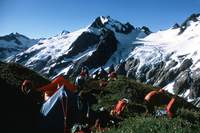
We made camp near White Rock Lakes on a platform looking across a valley
to the terrain we would have to negotiate next.
It was our practice to
select sites where people had camped before,
trying not to kill any more of the flora than necessary.
At every campsite,
we used our gas stoves to cook – there is little or no wood to burn
in these areas.
When we did find a place people had made a fire,
we added our trash to what was left of their mess,
burned it and packed up the remains to carry out.
Then we tried to remove all traces of the camp fire in hopes others
would not be tempted to burn what few gnarled,
beautiful scraps of wood were to be found.
This photo is a great example of how beautiful the area is.
Outside Magazine
refers to it as
“The Country’s Most Beautiful Mountaineering Route.”
The article,
published 23 August 2017,
starts with a photo taken from a few feet from here.
The next day we headed towards Spire Col.
This required 2,000 feet elevation gain with full packs on snow.
People were getting into shape now;
we made good enough time to stop and climb
Spire Point.
Eight people on Spire Point is a real crowd,
so not everyone could be on the route at once.
Having lead the way up and set protection,
I beat a hasty retreat down to the snow to make room for others.
There I met
Joe
and
Joan
Firey and two of their climbing partners waiting to climb.
Soon the members of my party left on the mountain,
some going up and some going down,
were so disorganized and yelling at each other I wanted to pretend I did
not know them.
I got people organized again and I am sure the Fireys were glad to see
the end of us.
Again,
the lack of an additional leader had proven to be a problem.
The ranger at Cascade Pass,
the hiker on Sahale Arm,
the Firey party and a group we met on the hike out were the only people
we encountered on the traverse.
The traffic jam at Spire Point cost us a lot of time,
so we arrived at a camp near Dome Peak late.
The next day four members of the party were tired and wanted to stay in
camp.
The remaining three joined me to climb
Dome Peak.
Dome Peak is actually a long ridge with many
“summits.”
Rather than climb only the main summit,
we decided to traverse the entire summit ridge.
The ridge extends to the left out of the picture.
For pictures of our very exposed traverse of the Dome Peak ridge and the
sparsely populated register we found at the summit,
click here.
This picture was taken looking north from the summit of Dome Peak and
shows the terrain Scott and I covered in the traverse,
starting from
Sahale, Boston
and
Forbidden.
The others covered a bit less,
having joined us when we returned to Cascade Pass.
For more pictures and maps of the route as done by others
(and with more peaks labeled)
see
here,
here
and
here.
Our climb of Dome Peak consumed a lot of time.
We were fortunate to find a relatively easy way down,
requiring only one 75 foot rappel and a lot of unroped downclimbing,
followed by a descent of a gully onto the glacier requiring a long
rappel.
We arrived late at camp for the third night in a row.
There appeared to be animosity brewing between Barb and Pete;
she decided to share a tent with me while he slept elsewhere.
Camping right next to Dome is not practical.
From our camp on Itswoot Ridge,
it was necessary to traverse over one mile to the Dome Glacier,
then negotiate the glacier to get to the mountain.
The day after climbing Dome,
I tried to interest a group in more climbing.
Two decided to start out a day early.
Barb was interested in climbing with me.
Pete and one other decided to stay in camp.
Two of the party who had not climbed Dome the previous day decided to
tackle the summit traverse.
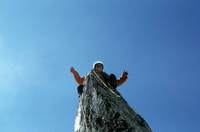
Barb and I set off for Hydramatic Spire
(high dramatic, not hydro-matic),
a moderately challenging,
short but spectacular climb of a high point on the ridge below Dome.
This picture shows me atop the spire;
note the yellow sling I placed around the top for a little security
before posing!
I have not been able to locate any accounts of anyone climbing
Hydramatic other than the original 1953 ascent and our 1971 ascent,
but I am sure a few other people have done it.
For more on our ascent of this airy perch,
click here.
Barb and I got back from our climb in good time,
but the party of two climbing Dome had not returned.
We were getting concerned as the sun was setting,
until we saw them pop out of the gully in the ridge and start the traverse
around the glacier back to camp.
They were beat after a long day of climbing,
but happy to have done such a spectacular route.
From the camp near Dome Peak,
there is over 12 miles of trail to the cars left at the south end of the
traverse.
The warm weather was melting snow so the streams were very high and we
had heard horror stories of the number of stream crossings needed.
We decided to take two days for the trip out to give us time to deal
with the difficulties and get to the cars in time to drive back 3 hours
on the very indirect route
to the north end to pick up the cars left there.
Fortunately we got advice from people who were on their way in and were
able to limit our difficulties to wading one stream barefoot,
crossing another on a log using our crampons and doing a bit of bush
whacking to avoid two crossings.
At our camp,
Barb and I chatted and cuddled while Pete slept.
A few days into the traverse,
we had begun to exchange notes on what meal we would order when we got
back to civilization.
My fantasy meal was a BLT.
Once vehicles had been retrieved and the group was back together,
the first order of business was to get to the nearest cafe.
I ordered two BLT meals and a dessert.
Immediately after the trip,
Pete was officially dumped and Barb was my girlfriend—for about 6
months.
While doing research to provide context for these pages,
I came across a new phenomenon:
bragging about how fast one has done the Ptarmigan Traverse.
The record for travel between Cascade Pass and the southern terminus
appears to be 18½ hours.
No mountains were climbed,
no camps made.
My reaction was to wonder why one would want to race through what is
arguably the most dramatic scenery in the contiguous 48 states?
I took nine days to do the traverse and only wish it was more.
Unfortunately,
I suspect this trend to
“speed traversing”
is a result of the restricted access to the area:
persons who never make camp are not required to have a permit.